Among the various factors that shape voyage efficiency, weather conditions play a pivotal role in planning a vessel’s operation. Amidst ever-growing navigational restrictions and regulatory pressures, maritime weather forecasting has become an integral component in maneuvering against the uncertain forces of weather.
After all, the weather at sea not only determines whether the voyage will be smooth-sailing or not, but also the speed and route simultaneously. Traditional weather routing methods and manual spreadsheet-based planning have proved redundant in a fast-evolving operating environment. For ship owners and operators, advanced technologies offer an opportunity to achieve the goal of voyage optimization in terms of time, costs, emissions, and safety.
The rise of real-time weather has revolutionized how weather forecasting is utilized to conduct operations based on the most efficient routes while lowering operating costs.
Beyond the Straight Line: The Evolution of Optimal Speed Routing
Traditional route planning aimed at finding out the shortest possible distance between two endpoints amidst constantly changing conditions. This approach didn’t always turn out to be efficient, considering the unpredictable nature of the weather.
Weather is also directly related to a core marine metric: fuel consumption. Wind speed and direction can lower hull resistance, which may cause the vessel to burn more fuel to maintain speed against the impact of headwinds.
Even when the winds are calm, the height and period of waves can determine how fast a vessel moves while increasing the engine load. When the current is favorable, the vessel is thrust forward without having to burn more fuel, whereas an adverse current can oppose forward motion and slow down speed.
Real-time data enables “Optimal Speed Routing where a vessel might take a longer journey so as to avoid clashing into a headwind or current. This allows the vessel to arrive faster without raising fuel consumption.
The Shift from Avoidance to Optimization
Voyage optimization centres on choosing the most efficient path based on three key variables: speed, power, and timing. Each of these variables is influenced by external environmental conditions like weather, sea state, current, and operational constraints.
A well-optimized voyage seeks to balance
A well-optimized voyage balances three priorities at once: maintaining safety margins, reducing fuel consumption, and achieving a precise ETA.
Speed is the most influential variable in this equation. Even small changes in RPM can have an outsized impact on fuel burn, sometimes increasing consumption exponentially when the vessel is pushed through heavy seas or strong headwinds.
When speed decisions are made late, for example, if a vessel slows down too much in bad weather and then has to accelerate aggressively to meet its ETA, operators pay twice: higher fuel consumption and higher emissions. Poorly timed speed changes also increase engine load variation, which can raise long-term maintenance risk.
This is why the industry is moving away from reactive “adjust as you go” planning. Modern decision-support systems give crews and planners a predictive view of the voyage.
By combining vessel behavior data with weather forecasts and operational targets, these tools recommend optimal speed profiles and highlight when route adjustments will save fuel without jeopardizing arrival time. Instead of compensating for delays after they occur, operators can anticipate them and choose the most efficient strategy in advance.
The Strategic Advantage: Why Weather Intelligence is Non-Negotiable
Integrating high-resolution weather data into voyage planning isn’t just about safety at sea. It’s about optimizing the entire commercial lifecycle of a vessel by embedding real-time intelligence into your routing. This allows operators to unlock four critical competitive advantages;
Drastic Operational Cost Reduction
Maritime logistics come with hidden costs. Since fuel makes up the highest operating cost for most vessels, efficient routing relies on optimizing for track and speed to cut down on fuel consumption. Avoiding high-resistance sea states yields significant fuel savings in line with unrestricted ETA and strict ETA requirements. As less time is spent on sea, crew overtime is reduced, while mariners can evade costly port penalty fees
Safety & Asset Protection
Extreme weather remains the primary cause of vessel loss and cargo damage globally. Awareness of the weather ahead helps vessels identify hazardous risk points like swell patterns and tropical depressions early on. This keeps the crew safe from accidental harm and reduces physical damage to the asset.
Accelerated Decarbonization & Compliance
Vessels are subject to strict IMO emissions targets, making smarter routing a viable way to improve your CII (Carbon Intensity Indicator) rating.
Staying out of inclement weather reduces engine strain and fuel burn, which contribute to the mandatory 2026 emissions cuts without spending on expensive hardware retrofits.
Predictive Scheduling & Reliability
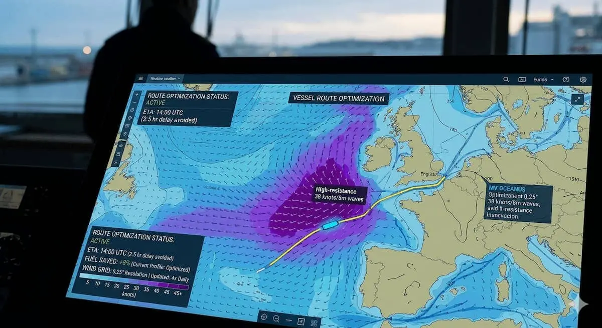
Port authorities report that 72% of port congestion issues are driven by the onset of weather events like high winds, heavy rainfall, fog, storms, and extreme cold/snow. Utilizing real-time, 0.25° grid forecasts allows vessels to anticipate adverse conditions and take appropriate safety measures. This allows “Just-in-Time” arrivals that mitigate vessel delays and operational disruptions that can spiral down across supply chains.
3. Closing the Gap: From Data to Actionable Intelligence
A common frustration for vessel operators is “data fatigue”—having too many sensors but no clear direction. Platforms are now filling this gap by providing Integrated Visibility Ecosystems.
For all its benefits, data fatigue is a real problem that frustrates vessel operators as they try to make sense of the data. With sensors all around them, they don’t know how to harness data into actionable insights. This creates a gap that is now being filled by adopting Integrated Visibility Ecosystems that provide a bird’s eye view to create a seamless, real-time perspective of the vessel’s environment.
| Feature | Legacy Planning | ShipSearch / Modern Standard |
| Data Source | Single NOAA/ECMWF feed | Multi-model (NOAA, ECMWF, Satellite, Buoys) |
| Update Frequency | Once every 24 hours | 4x daily real-time updates |
| Granularity | 1.0° (Broad regional) | 0.25° (Hyper-local maritime lanes) |
| Operational Link | Separated from chartering | Embedded in the ShipSearch marketplace |
How ShipSearch Positions the Future
For charterers and shipowners, ShipSearch serves as the central hub that represents a synergy of technical efficiency with commercial needs. Our platform intelligently integrates Ship Route Planning with Live Weather Data, so as to allow charterers to predict the ” Estimated Time of Arrival” with high-level accuracy.
Access to High-resolution weather data can help steer your vessel away from incidents and excessive hull stress. This not only protects the asset from physical impact but also preserves the long-term value of the ship
For charterers, Transparent weather tracking puts an end to the “black box” of transit. This means greater visibility into your vessel’s journey to reveal why it had to change course, reducing the possibility of conflict, demurrage, and late arrivals.