If you’ve ever had a container sit “in transit” for two weeks with zero updates, you already know the problem this article is about. Ocean freight has historically been a black box. A shipment leaves the origin port, and then… silence, until it either shows up or doesn’t.
Vessel tracking data changes that equation. It gives supply chain teams a live, verifiable picture of where cargo actually is, not where a spreadsheet says it should be. This matters more than ever: ocean carriers still miss their original scheduled arrival windows a significant share of the time, according to multiple years of industry schedule reliability reports (see Sea-Intelligence’s Global Liner Performance data for current figures). That unpredictability is exactly what tracking data is built to solve.
This guide breaks down what vessel tracking data actually is, how it works, how logistics and procurement teams use it day to day, and where it falls short. It’s written for supply chain managers, logistics analysts, freight forwarders, and anyone evaluating a visibility platform who wants the real picture, not a sales pitch.
What Is Vessel Tracking Data, Exactly?
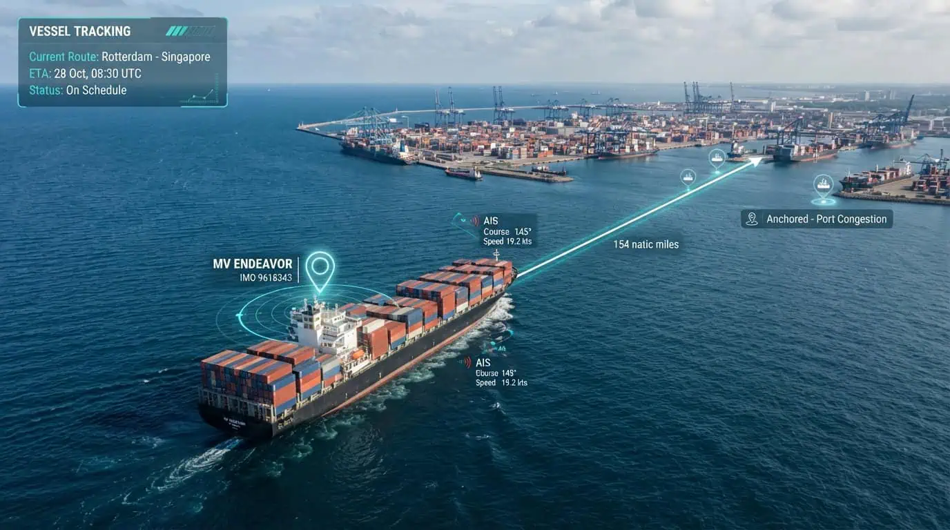
Vessel tracking data is location, movement, and status information collected from ships as they operate around the world. It typically includes:
- Vessel location data — real-time or near-real-time GPS coordinates
- Vessel ETA and arrival/departure data — estimated and actual times at ports
- Vessel identity details — IMO number, MMSI number, flag, vessel type
- Voyage details — speed, heading, draft, current port call, next port of call
The raw material behind almost all of this is AIS (Automatic Identification System) — a maritime safety technology, not originally a logistics tool. That backstory matters, and we’ll get into it below.
Where the Data Actually Comes From
Most people assume “vessel tracking” means satellites watching ships from space. That’s part of it, but not the whole story. There are three main data sources:
| Source | How it works | Coverage strength |
| Terrestrial AIS receivers | Land-based antennas pick up AIS signals from nearby ships | Strong near coastlines and ports, weak far offshore |
| Satellite AIS (S-AIS) | Satellites capture AIS signals from anywhere on the ocean | Strong on the open ocean, but with longer refresh intervals |
| Port and carrier systems | Terminal operating systems, carrier schedules, customs filings | Strong for port-specific status (berthed, gate-in, gate-out) |
A good maritime supply chain visibility platform blends all three, because each one covers a gap the others leave open. Terrestrial AIS alone loses ships once they’re more than about 40-50 nautical miles from shore. Satellite AIS fills that gap but usually updates less frequently than terrestrial coverage.
AIS Vessel Tracking — The Backbone of the System
AIS was mandated by the International Maritime Organization primarily to prevent collisions at sea, not to power logistics dashboards. Ships broadcast their position, speed, and identity over VHF radio frequencies every few seconds to few minutes, depending on vessel speed and type.
Commercial vessels over 300 gross tons on international voyages are required to carry AIS transponders under SOLAS (Safety of Life at Sea) regulations. That requirement is what makes AIS data for supply chain purposes viable at global scale — it’s not a niche tracking network, it’s a safety mandate that logistics companies have learned to repurpose.
Expert tip: When evaluating a vessel tracking data provider, ask directly what percentage of their positional updates come from satellite AIS versus terrestrial. Providers relying heavily on terrestrial-only feeds will show excellent accuracy in coastal regions and noticeably degraded accuracy mid-ocean — exactly where predictive ETA accuracy matters most for planning.
Why Supply Chain Visibility Depends on Ocean Data
Ocean freight moves roughly 80% of global merchandise trade by volume, according to UNCTAD’s Review of Maritime Transport. Yet ocean freight has traditionally had the weakest real-time visibility of any transport mode — far behind parcel or trucking, where GPS-based tracking has been standard for over a decade.
That gap creates real, measurable business problems:
- Inventory buffers get padded unnecessarily because planners can’t trust ETAs, so they hold extra safety stock “just in case.”
- Warehouse and labor scheduling breaks down when a vessel arrives three days early or a week late with no advance warning.
- Customer communication fails because customer service teams are quoting delivery windows based on outdated carrier schedules, not actual vessel position.
- Demurrage and detention costs stack up when teams don’t know a container is ready for pickup until it’s already accruing fees.
Vessel tracking data attacks this problem directly by replacing static, published schedules with live, position-based intelligence.
Static Schedules vs. Real-Time Vessel Tracking
| Carrier Published Schedule | Real-Time Vessel Tracking Data | |
| Update frequency | Days to weeks | Minutes to hours |
| Accounts for weather delays | No | Yes, reflected in updated position |
| Accounts for port congestion | Rarely | Yes, when paired with port data |
| Reflects vessel rerouting | No | Yes |
| Basis for ETA | Historical average transit time | Current speed, position, and route |
This is the core reason so many logistics teams have shifted from “track by schedule” to “track by vessel.”
How Vessel Tracking Data Is Used Across the Supply Chain
Vessel tracking isn’t a single use case — it feeds several different functions, often within the same organization.
1. Predictive ETA Management
Instead of relying on a carrier’s originally quoted arrival date, teams use live vessel location data combined with speed and route modeling to generate dynamic, continuously updated ETAs. This is arguably the single highest-value application of vessel ETA tracking, because so much downstream planning — trucking, warehouse labor, customer promises — hangs on that one date.
Example scenario: A vessel scheduled to arrive in Los Angeles on a Tuesday slows its speed mid-Pacific to save fuel or avoid arriving during port congestion. A carrier’s static schedule still shows Tuesday. Live tracking data catches the speed reduction and pushes the predicted ETA to Thursday — giving the receiving warehouse two extra days of lead time to adjust labor scheduling instead of finding out on Monday night.
2. Port Congestion Tracking
Port congestion tracking uses vessel data to monitor how many ships are waiting at anchor outside a port, how long vessels are dwelling before berthing, and how quickly terminals are processing cargo. During the 2021-2022 congestion crisis, dozens of vessels were queued outside ports like Los Angeles/Long Beach for weeks at a time — a situation that was only visible in near-real-time through vessel position data, since queued ships don’t show up in a carrier’s “on schedule” status.
3. Exception Management and Risk Mitigation
Supply chain risk management teams use vessel tracking to catch problems early:
- A vessel that stops transmitting AIS or goes off its expected route can signal a mechanical issue, piracy risk, or rerouting around a geopolitical hotspot.
- Sudden rerouting around chokepoints (e.g., vessels diverting around the Red Sea/Suez route since late 2023) shows up in tracking data well before it appears in any carrier advisory.
- Weather-related slowdowns are visible in real time rather than discovered after the fact.
4. Freight Procurement and Carrier Performance Scorecards
Procurement teams increasingly use historical vessel tracking and port call data to build objective carrier performance scorecards — comparing actual schedule reliability by carrier, trade lane, and vessel class, rather than relying on carriers’ self-reported on-time percentages.
5. Customer-Facing Visibility
Freight forwarders, 3PLs, and retailers increasingly expose vessel tracking data directly to their own customers through tracking portals, giving end customers self-service access to shipment status instead of routing every “where’s my container” question through a service rep.
Real-Time Vessel Tracking vs. Cargo/Container Tracking — What’s the Difference?
This is a common point of confusion, so it’s worth clarifying directly.
- Vessel tracking tells you where the ship is.
- Container tracking tells you where a specific container is, which may include vessel data but also gate-in/gate-out events, rail movements, and terminal handling.
- Cargo tracking data is the broadest term, potentially spanning ocean, rail, and truck legs of a single shipment’s journey.
A shipment’s full visibility picture typically requires vessel tracking as one layer, combined with terminal and inland data as the other layers. Vessel tracking alone tells you the ship is in port; it doesn’t tell you your specific container has cleared customs or been picked up.
Common mistake: Assuming “the vessel has arrived” means “my cargo is available.” In reality, containers can sit on a berthed vessel for days before discharge, and then sit in the terminal yard for additional days before being available for pickup. Treating vessel arrival as the finish line — rather than one checkpoint — is one of the most frequent planning errors in shipment tracking.
Choosing a Vessel Tracking Data Provider
Not all vessel tracking data is equal. Here’s what to actually evaluate.
Key Evaluation Criteria
- Data source blend — Does the provider combine terrestrial AIS, satellite AIS, and port/terminal data, or rely on just one?
- Update latency — How old is a “real-time” position by the time it reaches your dashboard?
- ETA prediction methodology — Is the ETA a dynamic model based on current speed/route, or a static carrier-fed date relabeled as “real-time”?
- Historical data depth — Can you pull historical vessel movements for carrier performance analysis, or only current positions?
- API and integration options — Can the data feed directly into your TMS, ERP, or visibility platform, or is it a standalone dashboard only?
- Port coverage — Some providers have much stronger data in major hub ports than in secondary or regional ports.
Pros and Cons of Vessel Tracking Data Platforms
Pros:
- Reduces reliance on manual carrier status checks and email chains
- Improves ETA accuracy, which directly improves labor and inventory planning
- Surfaces disruptions (congestion, rerouting, delays) earlier than traditional channels
- Supports data-driven carrier negotiations and performance reviews
- Can be integrated into customer-facing tracking tools
Cons:
- AIS signal gaps (mid-ocean, signal spoofing, transponders switched off) can create blind spots
- Data quality varies significantly between providers — cheap feeds often mean stale or terrestrial-only coverage
- Vessel-level tracking doesn’t automatically equal container-level visibility
- Integration and data cleanup can require real engineering effort, especially connecting multiple carriers’ formats
- Subscription costs can add up across multiple trade lanes and data providers
Common Mistakes to Avoid
- Treating vessel tracking data as a full visibility solution on its own. It’s one layer. Full shipment visibility needs container, terminal, and inland transport data layered on top.
- Ignoring AIS data gaps. A vessel “going dark” for a few hours mid-ocean is often normal (satellite handoff delays), not a red flag — but teams unfamiliar with AIS limitations sometimes over-react to routine gaps.
- Relying on a single data source. Terrestrial-only or satellite-only feeds each have blind spots; combining sources is what makes the data usable.
- Confusing vessel arrival with cargo availability. Covered above, but worth repeating — it’s the single most common planning error.
- Not validating ETA prediction logic. Ask providers whether their ETAs are dynamically modeled or just relabeled carrier schedule dates. This distinction has a major impact on accuracy.
Frequently Asked Questions
What is vessel tracking data used for in supply chain management?
It’s used to monitor ship location, predict arrival times, detect delays or rerouting, manage port congestion risk, and feed live status into logistics and customer-facing systems — replacing reliance on static carrier schedules.
How accurate is real-time vessel tracking?
Accuracy depends heavily on the data source mix. Near coastlines and in major ports, AIS-based tracking is typically accurate within meters and updates frequently. In open ocean, satellite AIS coverage means updates may only come every 10-60 minutes, and ETA predictions carry more uncertainty the further out they’re projected.
Is AIS data free or paid?
Raw AIS signals are technically public broadcasts, and some basic AIS tracking sites are free to use. However, enterprise-grade vessel tracking data — combining multiple sources, historical records, predictive ETAs, and API access — is typically a paid service, since aggregating, cleaning, and modeling that data at scale requires significant infrastructure.
Can vessel tracking data predict port congestion?
Yes, indirectly. By monitoring how many vessels are anchored or drifting near a port and how long vessels are taking to berth after arrival, tracking data can surface congestion trends before they show up in official port statistics.
Does vessel tracking work for all ship types?
It works for any vessel required to carry AIS, which includes essentially all commercial cargo vessels over 300 gross tons on international voyages. Smaller vessels, some fishing boats, and certain regional/domestic vessels may not be required to broadcast AIS, creating coverage gaps in those segments.
How is vessel tracking different from GPS tracking used in trucking?
Truck GPS tracking is typically a closed system — a company-owned device reporting to a private fleet management platform. Vessel tracking largely depends on a public, standardized broadcast (AIS) that multiple providers can independently receive and aggregate, which is why so many different tracking platforms exist for ocean freight.
Conclusion — Turning Vessel Data Into Supply Chain Action
Vessel tracking data has moved ocean freight from a black box into something much closer to real-time visibility — but only when it’s used correctly. The value isn’t in the raw position feed; it’s in what a team does with it.
Actionable takeaways:
- Don’t rely on a single AIS data source — blend terrestrial, satellite, and port data for real coverage.
- Use dynamic, tracking-based ETAs for planning, not static carrier schedule dates.
- Layer container and terminal data on top of vessel data — vessel arrival is a checkpoint, not the finish line.
- Use historical vessel data to build objective carrier performance scorecards for procurement leverage.
- Treat sudden route changes or AIS gaps as signals worth investigating, not noise to ignore.
Supply chain visibility isn’t about having more dashboards. It’s about having data you can actually plan around. Vessel tracking data, used well, is what makes that possible for the ocean leg of the journey.